
Open Access Journal of Agriculture Research (ISSN 2651-9003)
Research Article
Exploration of Precision Farming in Lowland Agriculture that is Oil Palm Plantation
Abd Hamid EHB, Shamsuri IHB, Nordin MHB and Haji Razali MHB*
Department of Plantation Technology and Management, University of Teknologi Mara, Malaysia
*Corresponding author: Muhammad Hudzari Bin Haji Razali, Faculty of Plantation Technology and Management,
University of Teknologi Mara, Malaysia, Tel: +60192208486; Email: hudzari@uitm.edu.my
Citation: Abd Hamid EHB, Shamsuri IHB, Nordin MHB and Haji Razali MHB (2019) Exploration of Precision Farming in Lowland Agriculture That Is Oil Palm Plantation. Open Acc J Agri Res: OAJAR-100021.
Received date: 11 November 2019; Accepted date: 18 November, 2019; Published date: 25 November, 2019
Abstract
Recent advances in Industrial Revolution 4 (IR4) claimed virtually that all industries will be integrating digitized with automation and robotics. In agriculture, Internet of Thing (IoT) of communication technology and Precision Farming have paved way to new trends to emerge in agriculture sector. This book introduced the development on contemporary solicitation to expedite the exploration on the Lowlands: Characteristics, Geology, and Exploration at the farm area of Faculty of Agrotechnology and Plantation, Universiti Teknologi MARA (Melaka), various tools used for this identification like Garmin etrex for Global Positioning System (GPS).
Keywords: Agriculture; Agro technology; Oil palm; Palm Plantation
Introduction
The oil palm, Elaeis guineensis, Jacq., is a perennial tree that is extensively planted as a monoculture crop in the plantation. It was introduced into Malaysia in the late of 19thcentury but it’s phenomenal growth commenced only in the mid-sixties under the crop diversification plan. From 97000 ha in 1965, the oil palm areas have increased to about 3.3 million ha in 1999. The annual export revenue of oil palm at about RM 18 billion between a year of 1997 and 1999 has brought much relieve to the nation during the recent financial crisis. However, the substantial increase in oil palm areas has not been commensurate by its productivity in terms of yield per ha. The national fresh fruit bunch (FFB) yields have stagnated at a relatively low level of 18.7 t/ha/yr (Table 1). The major plantation groups obtained similar trend with annual FFB yields fluctuating between 20 and 22 t/ha/yr since 1989 (Figure 1). These yields also fell short of their site yield potentials based on experimental results. The dismal yield performances have been attributed to many factors, among them are generalized agricultural inputs and monitoring, increased field size or management unit, declining management standards, lack of skilled workers and poor understanding of agronomy, but probably also exacerbated by the planting of oil palm on soil and climatic conditions previously deemed as marginal or unsuitable and the replanting of the rubber and cocoa on hilly, poor soils to oil palm. “To make precision farming work all areas of the Precision Agriculture wheel need to be addressed”. We do not intend to provide a comprehensive account of the future work required to introduce precision farming successfully to the oil palm plantations as it is beyond us.
Materials and Methods
Maximising Ffb Yield
According to the major factors affecting of oil palm yield and various researchers have quantified their effects. American Society of Yeild Plantation (ASYP) is present an outline of an empirical model [1], which has been and used commercially. The model predicted that site yield potential of a field is more or less predetermined after planting. Very little can be done to change the variable factors such as planting density and pattern until replanting more than 20 years later. Uneven planting with over-crowded spacing or high vacancies particularly in hilly, rugged terrain can result in poor uniformity in growth, light utilisation and exploitation of soil nutrients also water for maximum production.
The common problem will provide an excellent opportunity for precision farming by making full use of remote sensing and digital elevation model (DEM) to demarcate the terrain and coupled with soil maps for specific practices such as higher planting density for peat soil (160 palms per ha) and shallower soils (148 palms per ha). We can also automatically generate precise positions of the terraces for constant density planting in hilly areas as illustrated in Figure 1. The latter has always been a Planter’s dream but could be a reality now with the new tools and technologies.
In the Figure 4, the soil factors in the production equation of oil palm can be determine by detailed soil survey. This traditional process is essential for maximising FFB yields because the different marginal and problem soils in the oil palm plantations would require separate management strategies and agricultural practices [2] as shown in Figure 5. The importance is the identification of specific, main soil and agronomic limiting factors (e.g. shallow, lateritic soils) and reclassification of common soils in each field into practical management zones that bordered by roads and was located in GPS maps for ease the implementing the will prescribed remedial actions (Figure 6), demonstrated the impact of site-specific management, in a semi-commercial trial where each field was separating into lateritic and non-lateritic areas in 1986 (Table 1). The overall FFB yield of the 216-ha area increased from 18.4 t/ha/yr in the period of 1984-86 where uniform management was practised to 26.3 t/ha/yr in 1990-92 after implementation of site-specific inputs from 1986. At palm oil price of RM 1000/tonne, profit per hectare was 35% better in the period after site-specific management.
In Figure 3, the management zones can be delineating if FFB yield maps are available. Even in a relatively uniform field with similar management practices, there are certain areas of palm that have high and low yielding. For example, a patch of low yielding palms in the lower right-hand corner and western corner of Figure 6.
The identification of problem and nipping using this method in the buds are a steps to increase and maximising the FFB yields in the plantations. In the research by [3], we have used GIS and GPS to improve drainage in an estate and this problem requires an overview of the watershed on a regional basic, which is commonly beyond the estate boundary and covers the owners land or farm. With the new tools, we can easily compute the volume of excess water to drain, determine the direction of main drain, design a system of collection and field drains and compartmentalise areas for specific drainage design (Figure 7).
Lastly, Figure 7 shows the assessment of the extent and progress of pest damage in an oil palm plantation using remote sensing images where the ability to survey affected areas quickly is a big advantage in pest and disease management [4]. By using this method, we can also identify the direction of the pest movement, which is easterly in the example and the focal points where the next outbreak is likely to occur. This allows for differential treatments and timing of treatments to contain and ultimately eradicate the pest [5,6].
Conclusion
Precision farming has not been implement in the oil palm plantation to the best of knowledge although the tools and technologies associated with it was have been widely utilized. The major obstacles to precision farming in oil palm plantations are probably capital expenditure, lack of quantification of cost-benefit and risk of the new practices and resistant to change, which can be expected at this early stage of development. Currently most of the research is on adapting the new tools and technologies to solve immediate problems with little thoughts given to strategic and tactical approaches. Instead, it should suffice to list out some important areas where further research may be warranted. Mechanization of most operations is an absolute necessity for precision farming to materialize in oil palm plantations. The machines will allow data loggers, yield monitors, GPS, sensors etc. to be fitted for data collection. However, the errors and precision of the data and generated yield maps need further investigation.
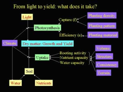
Figure 1: Primary factors influencing the site yield potential of oil palm in Malaysia.
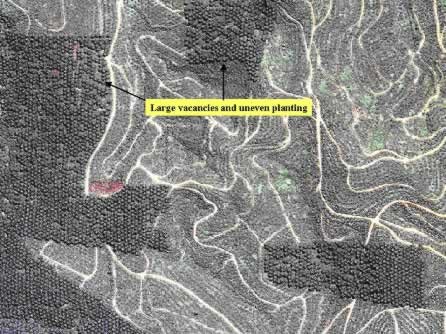
Figure 2: Ikonos remote sensing image (1 m resolution) shows areas with large vacancies and uneven plantings.
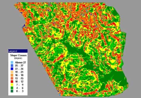
Figure 3: A 5 meter-pixel slope map derived from the DEM of the study area allows the demarcation of field by terrain.
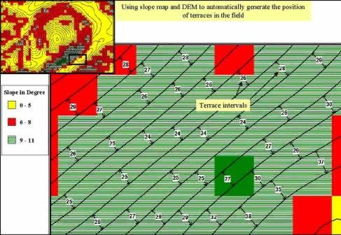
Figure 4: Using DEM and slope map to automatically generate the proposed terraces for constant density planting in oil palm plantation.
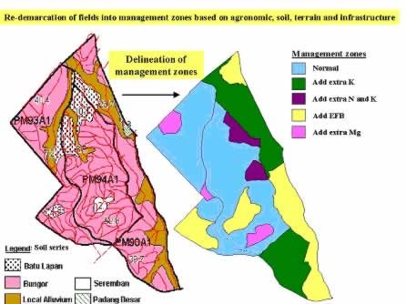
Figure 5: Creation of practical management zones for site-specific agricultural practices.
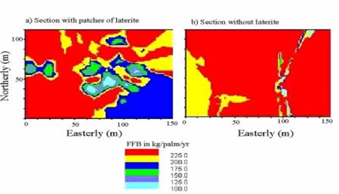
Figure 6: FFB yield maps of oil palm in 2 different sections of a relatively uniform field.
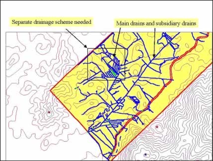
Figure 7: Design of drainage system in an oil palm plantation using GIS, GPS and DEM.
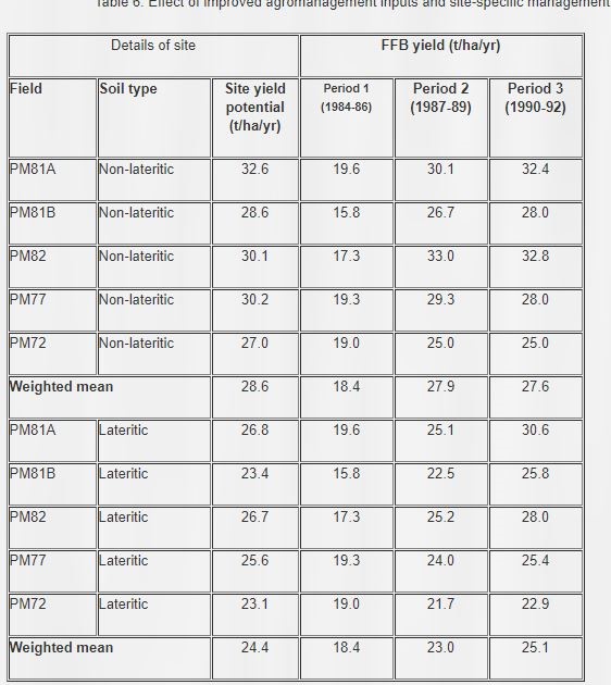
Table 1: Effect of improved agro management inputs and site-specific management on FFB yields.
Citation: Abd Hamid EHB, Shamsuri IHB, Nordin MHB and Haji Razali MHB (2019) Exploration of Precision Farming in Lowland Agriculture That Is Oil Palm Plantation. Open Acc J Agri Res: OAJAR-100021.