
Open Access Journal of Agriculture Research
Scientific Concept of Solving Various Agricultural Problems in Azerbaijan
B. H. Aliyev*, Z. H. Aliev
Institute of Erosion and Irrigation of ANAS, Azerbaijan
*Corresponding author: B.H.Aliyev, Institute of Erosion and Irrigation of ANAS, Azerbaijan.
Citation: Aliyev BH, Aliev ZH (2018) Scientific Concept of Solving Various Agricultural Problems in Azerbaijan. Open Acc J Agri Res: OAJAR-100004.
Received Date: 25 August, 2018; Accepted Date: 10 September, 2018; Published Date: 10 October, 2018
1. Evaluation State of Water and Land Resources of Azerbaijan
The total area of the republic is 8641500 hectares, of which 55 per cent of its ie: 4,756,500 hectares, is made suitable for agriculture. or 16.6 percent of the total area of 1,432,600 hectares, or some, of the irrigated lands. 1808400 hectares of the total balance of the land is one of arable land available for agriculture. It should be noted that of the 181,600 hectares of the total available arable land is under occupation by Armenian Aggressors Used. 224,700 hectares of arable land, permanent crops, 117.6 thousand hectares of hayfields, pastures 2560.0 thousand hectares, 45.7 hectares of fallow areas. Domestic households 258100 hectares (227600 hectares of arable land), 1.0388 million hectares included in the proportion of forest plantations areas.
Due to the increasing population, now that there are about 10-million people, the land use under non-agricultural projects and allocated for the construction of individual buildings and structures, is highly developed in certain types of soil erosion, and on the other hand, the rise of the groundwater level as a result of lifting in sea level rise is not the correct reference agromeliorative measures production areas in some farms, the use of a violation of the rules without environmentally dangerous technology of cultivation of crops, and agricultural machinery, the area per capita arable reduced from year to year [1-3]. If allocated to the share per person in 1959 was 0.36 ha of arable land, this figure was in 1970, 0.23 hectares, 0.21 hectares in 1979, while it decreased to 0,155 hectares in 2006 [4].
60% of the entire territory located the mountainous part of the republic. Because of the influence of natural and anthropogenic factors here, and can occur in all types of erosion [5]. As a result of our numerous research examining patterns of development problems of land degradation, and landscape in some regions, it was found that the erosion process is very widely distributed (especially in mountainous areas) in the country.
Currently, more than 42.8% of the entire territory of the country, 70-85% in some regions suffer from various degrees of erosion [5,6]. One of the biggest factors of water and irrigation erosion. The dominant republic in the duration of furrow irrigation and overlap, agro-technical measures, regardless of any land protection, agriculture, horticulture and livestock cause soil erosion [2,7]. However, the country is facing acute water shortage conditions.
Water resources of the country is 32.5 billion m3. In dry years, this figure is reduced by the amount 23,16mlrd. m3. The volume of water resources in the country to spend only 30%, while the remaining 70% of the flow through neighboring countries [4]. It should be noted that in conditions of constant shortage of water, dramatically uneven distribution of water in the country, despite the economic and environmental efficiency of crop irrigation, not primitive, traditional or pouring is carried out irrigation method.
The results of the study revealed that 96% of irrigated land is watered mostly traditional irrigation methods (furrow and overlap) by surface methods and the remaining 5% - while in the irrigated fields watered using advanced low-intensity water-saving irrigation systems. Therefore, and in the fields, the ground water level is increasing every Denham. In fact, in a number of areas, underground water, arable land available around 1000 thousand. Ha affected by salinization, which caused a particular danger in the disruption of the ecological balance of the country.
Currently, more than 53 thousand hectares of sown areas of the Kura-Araz lowland endured great danger as the strongly saline soils as a result of the floods, which came out of crop rotation plots of land the population of these regions of Azerbaijan, which require thorough rinsing of the soil of life-threatening salts of various kinds [2,4,6].
The results of monitoring studies revealed comparative figures for water availability, 3 Transcaucasia states: Georgia, Armenia and Azerbaijan, a follower of water resources at their 70, 25 and 10 billion km3, respectively.
Annual per capita water resource person in these countries, as the serial 11000, 3000, and 1500m3 / person. According to research, 2020, show the annual water resources per capita in Azerbaijan's turn in 2 times less than in Armenia, and 7 times less than in Georgia. It is believed that water is very important to the economy of each country, especially in the industrial and manufacturing sector, and in agriculture is a key element of life.
2. Steps in Destruction of Soil Erosion and Methods of Combating it in Azerbaijan
The degree of destruction of soil erosion:
Such views became the basis for the development of programs to protect land from erosion degradation for the whole country. Large-scale accounting was held only in those places for which the Plans or projects for the development and organization of the economy. In this model does not account for research technique
The degree of destruction of soil wind erosion:
In order to study the spread of habitats and development intensity erosion contact field and laboratory research methods were used. The phenomenon of soil erosion and areas of its distribution izisalis relatively -geographically, stationary and semi-stationary methods.
The decisive role of the terrain in the manifestation and development of well-known soil erosion. This is most clearly expressed by the factors of the nature of mountain areas are the slope of the surface, the depth of the local bases and exposure of slopes. Therefore, based on topographic maps at 1: 50,000 were drawn with the same name card erosion factors for the study area.
In drawing up the map the surface slopes following graduation were adopted: 0-30; 3-50; 5-70; 7-100; 10-150; 15-200; 20-250; 25-300; 30-450; and more than 450. For the distribution of land on the slopes of the surface used indicators weighted average value deviations proposed M.N.Zaslavskim (1979)
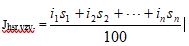
where Jhsr.vzv. - weighted average value deviations
i1; i2; in - slope dedicated circuits
s1; s2; sn-removed - the area allocated contours% of the total area.
Maps depth local erosion bases was compiled by determining the watersheds above the beds of rivers and their tributaries, as well as large ravines and 0-50;: To compile this card the following grading was adopted 50-100; 100-150; 150-200; 200-250; 250-300; 300-400; 400-500 and more than 500 m. [5]. Slopes exposure map was compiled on the basis of topographical and distinguished: the northern, northeastern, northwestern, eastern, southern, south-eastern, south-western exposure. During the classification S.S.Soboleva (which is described in the book I.F.Sadovnikova 1954) was applied soil erosion research. Based on this classification, the degree of erosion of soils were allocated as follows:
The territory of the Republic of Azerbaijan is located in the eastern part of the Caucasus, this includes the area of ??the Greater and Lesser Caucasus, Talysh zone, Kur River lowland. The total area of ??the republic is 86.6 thousand. Km2, about 40% of the land area consists of plains, the remaining 60% of the foothill and mountain areas. Climatic conditions varied republic being a mountainous country, the country at the same time has extensive lowlands, valleys, and in connection with a variety of surface topography has a varied climate. From the invasion of cold air masses from the north of the republic protects the main Caucasian ridge.
Depending on the height above sea level, climatic conditions vary. Raised in the mountains the average temperature is lowered. Of the 11 types under the Climate, established on the globe, we found 9 under climate types, there is no climate of savannas and tropical forests climate. Typical soil types are mountain-meadow turf, then mountain-forest soils in the foothills and piedmont plains of common gray-brown, in the arid zone of gray-brown, in the Talysh zone yellow land area.
Despite the small area of ??the republic has a variety of natural conditions and rich natural resources. One of the natural resources in Azerbaijan are pastures. The area of ??pastures is 22.3% in the Republic of the total area. Summer pasture make up 621 thousand. Hectares, 1.5 million hectares of winter, at rural pastures and hayfields are about 1 million hectares. It is known that the Azerbaijan Republic anciently different branch of the animal-production. Our region is rich in natural pasture and grassland, located in the alpine areas, it is a natural resource.
However, due to various circumstances, including soil erosion, these natural food resources lose their potential fertility. One of these circumstances is soil erosion.
Erosion is the destruction, erosion, as a geological term is the destruction of topsoil by wind and water.
The top sheet crust as a result of processes occurring in nature, is subject to various changes. This process can occur as a normal natural phenomenon, as intense as a result of anthropogenic load. In any of the cases 2 topsoil exposed washout. Regardless of the type of erosion is carried away by the most developed fertile upper accumulation horizon.
However, water streams and solid phase of soil nutrients are carried away from the fine fraction and depending on the degree of erosion, damage caused by erosion is different. It should also be noted that we, along with display of water erosion wind erosion - deflatio -also great.
Wind erosion is intensively manifested in the arid zone, where the dry climate, increased wind regime, the insignificance of precipitation contributes to the degradation of the vegetation cover. The intensity of wind erosion in comparison with the water is low. However, the damage caused by wind erosion agriculture enormous. Wind erosion on the one hand contributes to blowing soil, on the other hand the accumulation of particles in the form of a hill, the shifting sands poured vegetable and melon crops, roads, construction sites, squally winds tear off roofs from houses. Natural fodder lands are located on the eroded slopes have low productivity.
Scientific concept of solving various problems in Azerbaijan agrosystems surface improving natural hayfields and pastures is to improve water, air and food modes, taking care of herbage, the longest time to hold the grasslands in a state of economic value. Surface improvement expedient in the meadows, where the herbage remained 20-25% of forage grasses. On the grasslands and pastures with herbage worst surface improvement does not provide the desired effect, and should be a fundamental research on them.

Figure 1: Evaluation State of Water and Land Resources.
Citation: Aliyev BH, Aliev ZH (2018) Scientific Concept of Solving Various Agricultural Problems in Azerbaijan. Open Acc J Agri Res: OAJAR-100004.